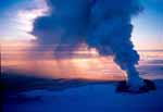
Piton de la Fournaise is a basaltic shield volcano on the eastern side of Reunion Island in the Indian Ocean. Piton de la Fournaise is one of the most active and the biggest volcanoes on Earth, along with Kilauea in the Hawaiian Islands (Pacific Ocean), Stromboli, Etna (Italy) and Mount Erebus in Antarctica. From the ocean floor, it is over 6,600 m tall. The base of the volcano has a diameter of 220 km.
Location: 21.23 S; 55.71 E.
Elevation: 2,631 m.
The Enclos Fouque, a caldera 8 kilometers wide, occupies the top part of the volcano. High cliffs known as remparts form the caldera's rim. The caldera is breached to the southeast into the sea. It is unstable and is in the initial stages of failure. It will eventually collapse into the Indian Ocean to form giant landslides like those in Hawaii.
Three calderas formed at about 250,000, 65,000, and less than 5000 years ago by progressive eastward slumping of the volcano. Numerous pyroclastic cones dot the floor of the calderas and their outer flanks.
Piton de la Fournaise summit cone, inside Caldera de l'Enclos Fouque, is characterized by two craters, Bory and Dolomieu (a 400 meter high lava shield). Bory Crater, west of Dolomieu, is smaller and inactive. Dolomieu Crater is the starting point of numerous recent eruptions.
Many craters and spatter cones can be found inside the caldera and the outer flanks of the volcano. At the beginning of the path that leads to the summit, there lies a noticeable small crater known as Formica Leo.
Two main axes of radial fracturing extend southeast and northeast of the summit. These alignments are recognized outside the Enclos by numerous eruptive vents and are interpreted as active rift zones. Unlike Hawaiian rift zones, which form narrow ridges extending tens of kilometers offshore, Piton de la Fournaise rift zones widen downslope.
Piton de la Fournaise has a mean time between eruptions of 10 months for the last two centuries and at least 125 recorded eruptions during the last century. Seventy-five percent of the eruptions have lasted less than one month, and 39 percent, less than one week. The lava output is generally 10 times lower than Kilauea's and two times lower than Etna's.
Most historical eruptions have originated from the summit and flanks of Dolomieu, a 400-m-high lava shield that has grown within the youngest caldera, which is 8 km wide and breached to below sea level on the eastern side. More than 150 eruptions, most of which have produced fluid basaltic lava flows, have occurred since the 17th century. Only six eruptions, in 1708, 1774, 1776, 1800, 1977, and 1986, have originated from fissures on the outer flanks of the caldera.
Over time, there has been two catastrophic eruptions, the first resulting in a nested caldera. Within this caldera formed a cone called Moyen, which suffered a similar fate and left a circular caldera measuring 7 km in diameter.
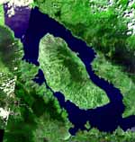
Piton de la Fournaise is also known as Reunion and is a twin shield volcano located in the western part of the Indian Ocean. The island of Reunion is made up of two volcanic mountains, Piton des Neiges (3,069 m) which covers the central part of the island and Piton de la Fouranaise (2,631 m) that is located on the eastern part of the island. These twin summits have been highly eroded over time.
Reunion is a French island in the Western Indian Ocean, about 700 km east of Madagascar and 200 km west of Mauritius. With Mauritius and Rodrigues Islands, they form the Mascarene Archipelago. The island is entirely volcanic and originates on the ocean floor at a depth of 4,000 meters.
Piton des Neiges emerged from the sea about 2 million years ago and has been inactive for 20,000 years. Deeply eroded, it occupies the northwestern two thirds of the island. Piton de la Fournaise, on the southeastern part of the island, became active more than 500,000 years ago on the flanks of Piton des Neiges.
Reunion island is the result of volcanic activity which begun around five million years ago. Lava erupted from a hot spot in the oceanic crust to form a huge cone rather like a worm cast. It is thought that the "island" eventually emerged from the sea around three million years ago and gradually, with succesive eruptions and much erosion became the island that is still evolving today. Two million years later, the first volcanic mass, the Piton des Neiges, was created. Deep under the ocean the "volcano" forms an immense cone with a base of 200 km and a total height of about 7000 m. The island, being located above a hot-spot in the Earth's crust, is slowly, and impercetibly, moving. It is made up of two distinct volcanoes - the Piton des Neiges (Snow Peak) which is now extinct and the younger and more active Piton de la Fournaise (Furnace Peak)
The origin of the Reunion Island is commonly attributed to a mantle hotspot. According to certain scientists, this hotspot first created the Deccan Traps, a large basalt province in India, about 65 million years ago. Its trace corresponds to Chagos-Lacadive Ridge, Mascarene Plateau, and Mauritius Island (created between 18 and 28 million years ago). Reunion became active about 5 million years ago, reaching the surface about 2 million years ago, and is the youngest island originating from this hotspot.
The Indian and African plates 65 and 40 million years ago. The black arrows represent absolute plate motions, with the fast motion of India 65 Myr ago, and the slow motion of Africa, corresponding to a time shortly after the Reunion plume head is thought to have arrived at Earth’s surface. By 40 Myr ago, the influence of the plume had waned: the Indian plate had slowed down considerably and the African plate had resumed its former direction and speed.
The Reunion hotspot is a volcanic hotspot which currently lies under the Island of Reunion in the Indian Ocean. The Chagos-Laccadive Ridge and the southern part of the Mascarene Plateau are volcanic traces of the Reunion hotspot.
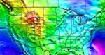
Reunion hotspot track extends from India to the island of Reunion. About 65 million years ago present-day India was above the hot spot and great volumes of basaltic lava erupted to produce the Deccan Traps.
As the plate moved northeast over the hot spot more volcanic centers formed:
- the Maldives from 55-60 million years ago;
- the Chagos Ridge 48 million years ago;
- the Mascarene Plateau 40 million years ago;
- the Mauritus Islands from 18-28 million years ago.
- the youngest volcanoes, Piton des Neiges and Piton de la Fournaise, formed in the last 5 million years.
The summits of Piton des Neiges and Piton de la Fournaise volcanoes make the island of Reunion. Piton des Neiges is extinct. Piton de la Fournaise is one of the most active volcanoes on Earth.
Around 70 million years ago, the tectonic plate that now includes the Indian subcontinent lay northeast of Madagascar. Suddenly, it started moving incredibly quickly - by geological standards - at 10 centimetres per year. Around the same time, a spate of huge volcanoes occurred at the Deccan Plateau, sited in the area that is now India. Molten lava was thrown over around 1.5 million square kilometres.
The Indian subcontinent tectonic plate sat over a powerful mantle plume which began around 70 million years ago, around what is now the Reunion Islands. This rising mass of hot rock hit the Earth's crust and spread out. The pushing force of the mantle plume sent the Indian plate hurtling towards what is now Asia.
The Reunion mantle plume to be responsible for:
- the mass volcanism at the Deccan Plateau;
- the African tectonic plate to slow down for around 5 million years.
After the plume subsided, the Indian tectonic plate slowed to a more normal geological movement of around a few centimetres each year, whereas the African plate sped up. The movement of these two plates in sync, always countering each other, provides strong evidence that a powerful mantle plume was responsible for their motion.
Imaging a mantle plume under the hotspot of La Reunion. Reunion upper mantle structure.
Seven Earth's hotspots as qualifying candidates for deepest, primary plumes:
- Hawaii, Easter and Louisville in the Pacific hemisphere;
- Iceland, Afar, Reunion and Tristan in the Indo-Atlantic hemisphere.
Forty years after the existence of mantle plumes was first hypothesised, it remains controversial whether such upwellings from the deepest part of the earth’s mantle exist, and whether they contribute substantially to the heat budget of the solid earth.
Distribution of the 49 hotspots (black circles) superimposed on a section at (a) 500 km and (b) 2850 km depths through Ritsema et al.’s tomographic model for shear wave velocity (VS). Color code from 32% (red hues) to +2% (blue hues) velocity variation.
Existing and planned seismic stations in the SW Indian Ocean. RHUM-RUM Passive Seismic Experiment.
Reunion hotspot is one of the most active volcanoes in the world, and its hotspot track leads unambiguously to the Deccan Traps of India, one of the largest flood basalt provinces on Earth, which erupted 65 Ma ago. The genesis and the origin at depth of the mantle upwelling and of the hotspot are still very controversial.
The volcano Reunion Island is one of the strongest candidates worldwide for a hotspot underlain by a deep, mantle plume.
RHUM-RUM (Reunion Hotspot and Upper Mantle - Reunions Unterer Mantel) is a French-German passive seismic experiment designed to image an oceanic mantle plume from crust to core beneath Reunion Island, and to understand these results in terms of material, heat flow and plume dynamics.
From 2011 to 2013 was created a large seismological data set around the Reunion island volcanic hotspot. The main objective is to study whether this intraplate hotspot is underlain by a deep (mantle plume), or what else might have been driving its intense volcanic activity over the past 65 million years. This mixed terrestrial / ocean-bottom data set is planned to handle modern seismic body-wave tomography technologies. The main goal is seismically illuminate the entire column of mantle beneath Reunion and to obtain 3-D images of mantle structure from crust to core.
In the RHUM-RUM project, 57 German and French ocean-bottom seismometers (OBS) have been deployed in 2012 over an area of 2000 km x 2000 km centered on Reunion Island, using the Marion Dufresne II research and supply vessel. They will be recovered in 2013 by the Meteor Research/Survey Vessel.
The one-year OBS deployment (Oct. 2012 – Oct. 2013) is augmented by terrestrial deployments in the Iles Eparses in the Mozambique Channel, in Madagascar, Seychelles, Mauritius, Rodrigues and Reunion Islands. A significant number of OBS will be also distributed along the Central and South West Indian Ridges to image the lower-mantle beneath the hotspot, but also to provide independent opportunity for the study of these slow to ultra-slow ridges and of possible plume-ridge interactions.
The area around Reunion Islands is still a hotspot for volcanic activity, even though the plume has now spluttered out. Could mantle plumes be responsible for more of our present mountain ranges, volcanoes and continents? Whilst not all scientists agree that mantle plumes are responsible for the movement of whole continents, the latest research should shed new light on the way we think about the Earth's geological features.

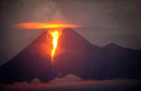


. Source: Gaba (2007).") Piton de la Fournaise summit cone, inside Caldera de l'Enclos Fouque, is characterized by two craters, Bory and Dolomieu (a 400 meter high lava shield). Bory Crater, west of Dolomieu, is smaller and inactive. Dolomieu Crater is the starting point of numerous recent eruptions.
Piton de la Fournaise summit cone, inside Caldera de l'Enclos Fouque, is characterized by two craters, Bory and Dolomieu (a 400 meter high lava shield). Bory Crater, west of Dolomieu, is smaller and inactive. Dolomieu Crater is the starting point of numerous recent eruptions.
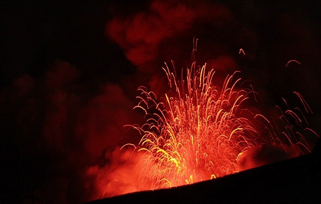
 interferograms of the Piton de la Fournaise volcano exhibit clear fringes patterns centred on the Soufriere pit crater, on the external northern flank of the summit Dolomieu caldeira. The range change pattern is asymmetric with respect to the eruptive fissures.") Many craters and spatter cones can be found inside the caldera and the outer flanks of the volcano. At the beginning of the path that leads to the summit, there lies a noticeable small crater known as Formica Leo.
Many craters and spatter cones can be found inside the caldera and the outer flanks of the volcano. At the beginning of the path that leads to the summit, there lies a noticeable small crater known as Formica Leo. Piton de la Fournaise has a mean time between eruptions of 10 months for the last two centuries and at least 125 recorded eruptions during the last century. Seventy-five percent of the eruptions have lasted less than one month, and 39 percent, less than one week. The lava output is generally 10 times lower than Kilauea's and two times lower than Etna's.


