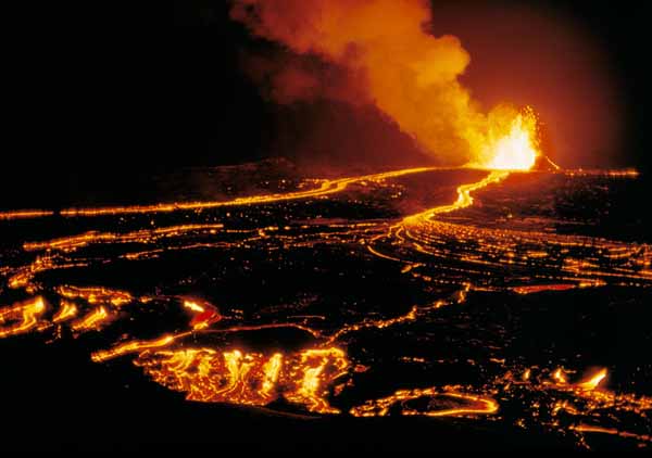
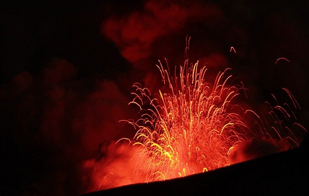
Kilauea Volcano, Hawaii.
Table of contents.
Introduction.

Kilauea is a currently active shield volcano in the Hawaiian Islands, and the most active of the five Hawaiian volcanoes. Kilauea is the most active volcano on the Earth. Located along the southern shore of the island. Coordinates: 19°25'16"N; 155°17'13"W, Summit Elevation: 1247 m.
Kilauea's current eruption dates back to January 3, 1983, and is by far its longest-lived historical period of activity, as well as one of the longest-lived eruptions in the world; as of January 2011, the eruption has produced 3.5 cubic kilometers of lava and resurfaced 123.2 km2 of land.
Volcano Kilauea is between 300,000 and 600,000 years old. Volcano emerged above sea level about 100,000 years ago. It is the second youngest product of the Hawaiian hotspot and the current eruptive center of the Hawaiian–Emperor seamount chain.
Structurally, Kilauea has a large, fairly recently formed caldera at its summit and two active rift zones, one extending 125 km east and the other 35 km west, as an active fault line of unknown depth moving vertically an average of 2 to 20 mm per year.
 Map of Kilauea Volcano showing the summit caldera, southwest and east rift zones, Puu Oo, roads, and several communities located on the volcano's flanks. Map by J. Johnson, 2000.
Kilauea has two rift zones radiating from its summit. One rift zone leading 125 km out to the east. Second rift zone 35 km long and trending towards the southwest. Tectonic extension along both rift zones is causing Kilauea's bulk(body) to slowly slide seaward off its southern flank at a rate of 6 to 10 cm, centered on a basal decollement fault line 7 to 9 km beneath the volcano's surface. The eastern rift zone is a dominant feature on the volcano; it is almost entirely covered in lava erupted in the last 400 years, and at its crest near the summit is 2 to 4 km wide. Non-localized eruptions, typical of rift zone activity, have produced a series of low-lying ridges down the majority of the east rift zone's length. Its upper segment is the most presently active section of the volcano, and is additionally the site of a number of large pit craters; its lower extremity reaches down Kilauea's submerged flank to a depth of more than 5,000 m.
By contrast, the much smaller southwestern rift has been quiet since a rifting episode in 1974, and has not been involved in the current eruptive cycle at all. The southwestern rift zone's extremity is also underwater, although its submarine length is more limited. The rift zone also lacks a well-defined ridge line or a large number of pit craters, evidence that it is also geologically less active than its eastern cousin.
Map of Kilauea Volcano showing the summit caldera, southwest and east rift zones, Puu Oo, roads, and several communities located on the volcano's flanks. Map by J. Johnson, 2000.
Kilauea has two rift zones radiating from its summit. One rift zone leading 125 km out to the east. Second rift zone 35 km long and trending towards the southwest. Tectonic extension along both rift zones is causing Kilauea's bulk(body) to slowly slide seaward off its southern flank at a rate of 6 to 10 cm, centered on a basal decollement fault line 7 to 9 km beneath the volcano's surface. The eastern rift zone is a dominant feature on the volcano; it is almost entirely covered in lava erupted in the last 400 years, and at its crest near the summit is 2 to 4 km wide. Non-localized eruptions, typical of rift zone activity, have produced a series of low-lying ridges down the majority of the east rift zone's length. Its upper segment is the most presently active section of the volcano, and is additionally the site of a number of large pit craters; its lower extremity reaches down Kilauea's submerged flank to a depth of more than 5,000 m.
By contrast, the much smaller southwestern rift has been quiet since a rifting episode in 1974, and has not been involved in the current eruptive cycle at all. The southwestern rift zone's extremity is also underwater, although its submarine length is more limited. The rift zone also lacks a well-defined ridge line or a large number of pit craters, evidence that it is also geologically less active than its eastern cousin.
|
 Cutaway view of the east rift zone of Kilauea Volcano, Hawaii
Diagram by J. Johnson, 2000
Cutaway view (not to scale) of Kilauea Volcano shows the pathway of molten rock during the eruption of Puu Oo, cinder-and-spatter cone on Kīlauea located on the east rift zone about 20 km from the caldera. Molten rock moves from the magma reservoir beneath the caldera through the east rift zone to Puu Oo. When molten rock erupts as lava from Puu Oo, it flows either onto the surface or through a lava-tube system 10-11 km to the sea.
During episode 54 (January 30, 1997), lava erupted from Napau Crater about 4 km uprift from Puu Oo. The rift zone widened about 1.8 m in Napau and 36 cm about 2 km uprift, as magma forced a pathway to the surface. Chemical studies of lava samples from episode 54 indicate that two separate and distinct bodies of magma, stored in the rift zone near Napau Crater for many years, supplied lava for the eruptive activity.
Cutaway view of the east rift zone of Kilauea Volcano, Hawaii
Diagram by J. Johnson, 2000
Cutaway view (not to scale) of Kilauea Volcano shows the pathway of molten rock during the eruption of Puu Oo, cinder-and-spatter cone on Kīlauea located on the east rift zone about 20 km from the caldera. Molten rock moves from the magma reservoir beneath the caldera through the east rift zone to Puu Oo. When molten rock erupts as lava from Puu Oo, it flows either onto the surface or through a lava-tube system 10-11 km to the sea.
During episode 54 (January 30, 1997), lava erupted from Napau Crater about 4 km uprift from Puu Oo. The rift zone widened about 1.8 m in Napau and 36 cm about 2 km uprift, as magma forced a pathway to the surface. Chemical studies of lava samples from episode 54 indicate that two separate and distinct bodies of magma, stored in the rift zone near Napau Crater for many years, supplied lava for the eruptive activity.
|
Lavas younger than 1,000 years cover 90 percent of the volcano; the oldest exposed lavas date back 2,800 and 2,100 years.
The first well-documented eruption of Kilauea occurred in 1823, and since that time the volcano has erupted repeatedly. Most historical eruptions have occurred at the volcano's summit or its southwestern rift zone, and are prolonged and effusive in character.
To Top
Geology. The Hawaiian hotspot.

Like all Hawaiian volcanoes, Kilauea was created as the Pacific tectonic plate moved over the Hawaiian hotspot in the Earth's underlying mantle.
The Hawaii island volcanoes are merely the most recent evidence of this process that, over 70 million years, has created the 6,000 km-long Hawaiian–Emperor seamount chain. The prevailing, though not completely settled, view is that the hotspot has been largely stationary within the planet's mantle for much, if not all of the Cenozoic Era. However, while the Hawaiian plume is well-understood and extensively studied, the nature of hotspots themselves remains fairly enigmatic.
The oldest volcano on the Hawaii island, Kohala, is more than a million years old, and Kilauea, the youngest, is believed to be between 300,000 and 600,000 years of age; Loihi Seamount on the island's flank is even younger, but has yet to breach the surface. Thus it is the second youngest volcano in the Hawaiian – Emperor seamount chain, a chain of shield volcanoes and seamounts extending from Hawaii to the Kuril–Kamchatka Trench in Russia.
Following the pattern of Hawaiian volcanics, Kīlauea would have started out as a young submarine volcano, gradually building itself up through subsurface eruptions of alkali basalt before emerging from the sea with a series of explosive eruptions about 50,000 to 100,000 years ago. Since then, the volcano's activity has likely been as it is now, a continual stream of effusive and explosive eruptions of roughly the same pattern as its activity in the last 200 or 300 years.
Kilauea has a large summit caldera, measuring 4 by 3.2 km with walls up to 120 m high, breached by lava flows on the southwestern side. Kilauea formed over several centuries, with its construction estimated to have begun about 500 years ago,and that its present form was finalized by a particularly powerful eruption in 1790. A major feature within the caldera is Halemaumau, a large pit crater and one of Kilauea's most historically active eruption centers. The crater is approximately 920 m in diameter and 85 m deep, and its form has varied widely through its eruptive history; the floor of the Halemaumau Crater is now mostly covered by flows from its most recent eruption, in 1974.
To Top
Historical eruptions at Kilauea.
All historical eruptions at Kilauea have occurred at one of three places:
- Summit caldera: half of Kilauea's historical eruptions have occurred at or near Kilauea's summit caldera. Activity there was nearly continuous for much of the 19th century, capped by a massive explosive eruption in 1924 before petering out by 1934.
- Eastern rift zone: recent activity has mostly shifted to Kilauea's eastern rift zone, the site of 24 historical eruptions, located mostly on its upper section.
- Southwestern rift zone: the volcano's southwestern rift zone has been relatively quiet, and has only been the site of five events to date.
To Top
Tiltmeters track inflation and deflation of Kilauea's summit caldera.

Eruptions of Puu Oo on the east rift zone of Kilauea Volcano between 1983 and 1986 were accompanied by a remarkable pattern of ground tilt at the volcano's summit about 20 km away. Before erupting at Puu Oo, magma first moved into the underground summit reservoir beneath the summit caldera then into the volcano's east rift zone. As the magma moved from the summit reservoir toward Puu Oo, the ground at the summit subsided, which was recorded by tiltmeters on the west rim of the caldera.
To Top
Magma inflates and deflates Kilauea Volcano.

View northeast across Kilauea caldera. Halemaumau in low center is 1 km in diameter. More than 40 years of tiltmeter records show that magma moving beneath the summit caldera of Kilauea Volcano forces the ground to move up and down, sometimes by as much as 2 m.

This graph shows a one-year record of tilt from the Uwekahuna tiltmeter located on rim of Kilauea's caldera. When the tiltmeter record showed an increase in slope angle (microradians) the ground was tilting away from the caldera, which indicates the summit area was inflating with magma. Then, when lava within Puu Oo filled and overflowed the crater or began fountaining, the summit tiltmeter record suddenly showed a decrease in slope angle or deflation. After the eruption, the tiltmeter once again recorded a steady outward tilt.
To Top
Magma pathways beneath Kilauea Volcano.

Magma rising into Kilauea Volcano first enters a principal storage reservoir beneath its summit caldera. The magma may then erupt at the summit or move through one of two principle pathways (rift zones) beneath the flanks of Kilauea (arrows show direction). This movement of magma down the rift zones causes the summit area to subside, which is recorded by tiltmeters as an inward tilt of the caldera rim. When magma is not moving down one of the rift zones, the summit caldera inflates slowly as shown by an increase in ground tilt, indicating magma is rising into the summit reservoir.

A series of craters, cinder cones, and ground fractures leading from the summit caldera of Kilauea Volcano marks the east rift zone. Lline shows approximate location of rift zone between caldera and Pu`u `O`o (Puu Oo). The rift zone consists of a series of fractures within the volcano through which magma moves from the summit reservoir. Kilauea's summit caldera and Halemaumau crater are in foreground. A gas plume from Puu Oo rises in the background.
The remarkable tilt pattern at the caldera in the 1980's showed that the summit magma reservoir is often in delicate balance with the reservoir system beneath the east rift zone. The pattern of tilt at Kilauea helps determine when magma is on the move down one of the rift zones and when it might erupt.
To Top
Sources of information:
1. Websites:
- http://hvo.wr.usgs.gov/activity/kilaueastatus.php
- http://hvo.wr.usgs.gov/multimedia/
- http://en.wikipedia.org/wiki/Kīlauea
- http://www.volcanodiscovery.com/kilauea.html
To Top
|