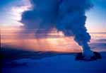
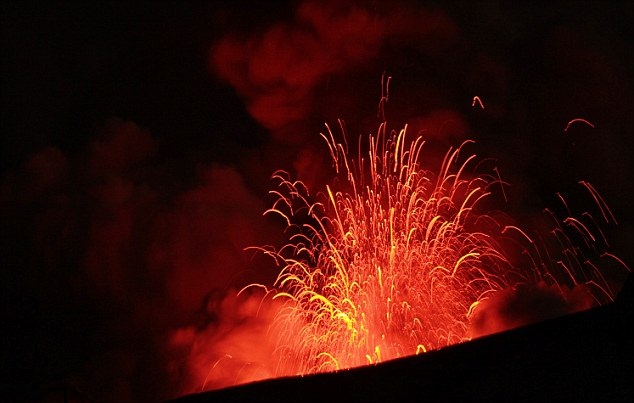
Two massive eruptions occurred Wednesday (April 22, 2015) and early Thursday (April 23, 2015) at Chile's Calbuco volcano, spewing ash and hot rocks as high as 9 km into the air, according to Argentina's meteorology service. Webcams showed yet another eruption Friday (April 24, 2015).
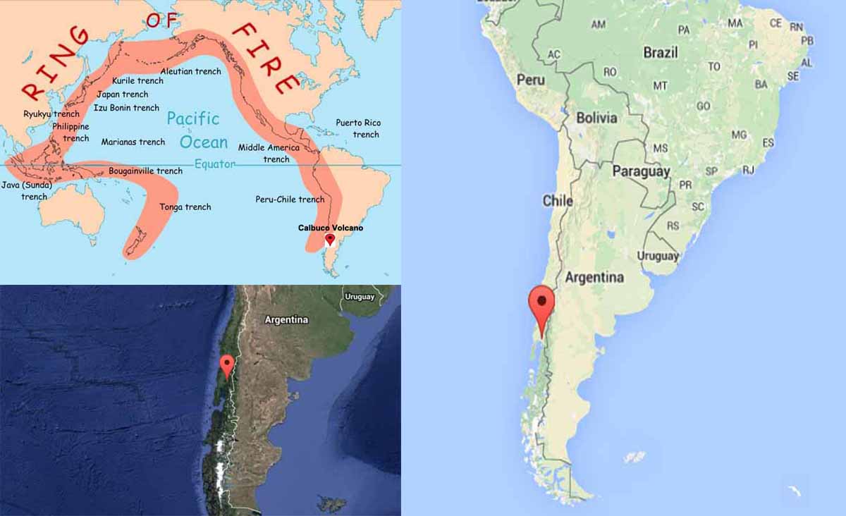
Calbuco volcano is a Late Pleistocene-Holocene composite stratovolcano 2003 m / 6,571 ft. in Southern Chile and Argentina (South America).
Coordinates: -41.33°S / -72.61°W
Typical eruption style: explosive.
Calbuco stratovolcano located southeast of Llanquihue Lake and northwest of Chapo Lake, in the Los Lagos Region. The volcano and the surrounding area are protected within Llanquihue National Reserve. It is a very explosive andesite volcano whose lavas usually contain 55 to 60% silicon dioxide (SiO2). It underwent edifice collapse in the late Pleistocene, producing a volcanic debris avalanche that reached the lake.
Calbuco has had at least 10 eruptions since 1837. Calbuco volcano eruptions: 1893-94. One of the largest historical eruptions in southern Chile took place there in 1893–1894. Violent eruptions ejected 30-cm bombs to distances of eight kilometres from the summit crater, accompanied by voluminous hot lahars. 1895, 1906, 1907, 1909, 1911-12, 1917. Strong explosions occurred in April 1917, and a lava dome formed in the crater accompanied by hot lahars. 1929. Another short explosive eruption in January 1929 also included an apparent pyroclastic flow and a lava flow. 1961. A major eruption of Calbuco in 1961 sent ash columns 12–15 km high and produced plumes that dispersed mainly to the south east and two lava flows were also emitted. 1972. There was a minor, four-hour eruption on August 26, 1972. 1996. Strong fumarolic emission from the main crater was observed on August 12, 1996. 2015. Calbuco had been quiet since a four-hour eruption on August 26 1972, except for an episode of gas emission from fumaroles on 12 August 1996.
Calbuco volcano as a result of plate tectonic processes.
Calbuco and other volcanoes in the Andes are present as a result of plate tectonic processes, which also cause earthquakes in the region.
The floor of the Pacific ocean (actually the Nazca Plate) is being pushed below South America which leads to melting at depth which forces magma upwards to feed the volcanoes. Because seawater has been transported into the melting zone, the magma contains gases such as water vapour and carbon dioxide, and the violent expansion of gas bubbles is what makes eruptions at these volcanoes so explosive.
Calbuco lavas are porphyritic andesites, which contain a wide variety of crustal xenoliths.
It is suggested that basalts were produced by lower extents of mantle melting than basalts from Osorno and other stratovolcanoes of Southern Volcanic Zone of the Andes probably as a result of lower water content in the source of MEC (minor eruptive centers) basalts.
Calbuco andesites formed from basaltic parents similar to Osorno basalts, by moderate pressure crystallization of a hornblende-bearing assemblage accompanied by crustal assimilation.
Hornblende stability in the Calbuco andesites was promoted by the assimilation of hydrous metasedimentary crustal rocks, which are also an appropriate endmember for isotopic trends, together with magma storage at mid-crustal depths. The unique characteristics of Calbuco volcano, i.e. the stability of hornblende at andesitic SiO2 contents, low 143Nd/144Nd and high 87Sr/86Sr, and abundant crustal xenoliths, provide evidence for crustal assimilation that is not apparent at more northerly volcanoes in the Southern Volcanic Zone of the Andes.
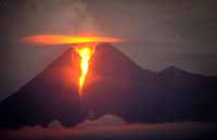
Eruptions like these are particularly significant because they have the potential to produce pyroclastic flows, which are fast-moving ground-hugging currents of ash and hot air, triggered when a rising ash column collapses. A pyroclastic flow is a superheated current of gas and rock that can destroy nearly everything in its path and travel at speeds upwards of 200km to 300km per hour. These are deadly – and the 20km radius evacuation zone wisely remains in place in case the volcano (quiet during most of April 24) wakes up again.
Chile, on the Pacific Ring of Fire has the second largest chain of volcanoes in the world after Indonesia, including around 500 that are potentially active.
The Ring of Fire is a string of volcanoes and earthquakes, around the Pacific Ocean. Approximately 90% of all earthquakes occur along the Ring of Fire, and the ring includs 75% of all active volcanoes of the Earth.
It has the shape of a horseshoe.
The chain of 452 volcanoes stretches from the New Zealand, up through Japan, across the Bering Strait, down along the coast of North America and South America, and stretches to Antarctica..
Geologic features along the Ring of Fire include volcanoes, ocean trenches, mountain trenches, hydrothermal vents, and sites of earthquake activity.


.") Calbuco and other volcanoes in the Andes are present as a result of plate tectonic processes, which also cause earthquakes in the region.
Calbuco and other volcanoes in the Andes are present as a result of plate tectonic processes, which also cause earthquakes in the region. Calbuco lavas are porphyritic andesites, which contain a wide variety of crustal xenoliths.
It is suggested that basalts were produced by lower extents of mantle melting than basalts from Osorno and other stratovolcanoes of Southern Volcanic Zone of the Andes probably as a result of lower water content in the source of MEC (minor eruptive centers) basalts.
Calbuco lavas are porphyritic andesites, which contain a wide variety of crustal xenoliths.
It is suggested that basalts were produced by lower extents of mantle melting than basalts from Osorno and other stratovolcanoes of Southern Volcanic Zone of the Andes probably as a result of lower water content in the source of MEC (minor eruptive centers) basalts. , ocean trenches, mountain trenches, hydrothermal vents, and sites of earthquake activity. Map courtesy USGS.") The Ring of Fire is a string of volcanoes and earthquakes, around the Pacific Ocean. Approximately 90% of all earthquakes occur along the Ring of Fire, and the ring includs 75% of all active volcanoes of the Earth.
The Ring of Fire is a string of volcanoes and earthquakes, around the Pacific Ocean. Approximately 90% of all earthquakes occur along the Ring of Fire, and the ring includs 75% of all active volcanoes of the Earth. 


