Introduction
The 2017 Chiapas earthquake struck at 23:49 CDT on 7 September in the Gulf of Tehuantepec off the southern coast of Mexico, near state of Chiapas, approximately 87 kilometres (54 mi) south of Pijijiapan, with a Mercalli intensity of IX (Violent). The magnitude was estimated to be Mw 8.1.
The earthquake caused some buildings in Mexico City to tremble, prompting people to evacuate. It also generated a tsunami with waves of 1.75 metres (5 ft 9 in) above tide level; and tsunami alerts were issued for surrounding areas. It was also the second strongest recorded in the country’s history, behind the magnitude 8.6 earthquake in 1787, and the most intense recorded globally, so far in 2017.
On 6 September 2017, several earthquake alarms in Mexico City were mistakenly activated and prompted the evacuation of buildings. The incident prompted a review of the system.
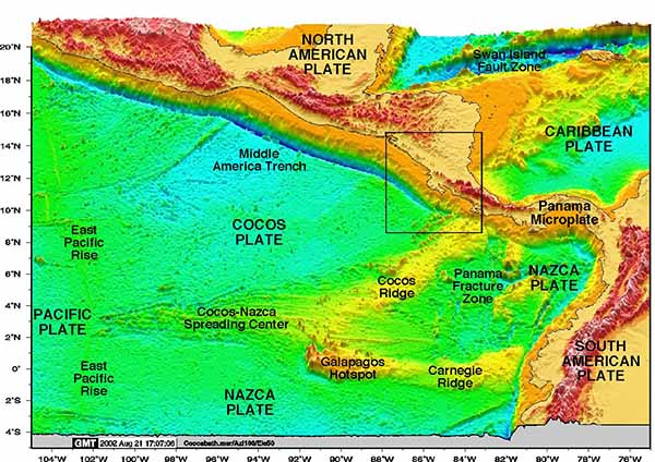
According to the National Seismological Service (SSN) of Mexico, the epicenter was located in the Gulf of Tehuantepec, about 137 kilometres (85 mi) southeast of Tonalá, Chiapas. The United States Geological Survey (USGS) reported that the epicenter was about 87 kilometres (54 mi) southwest of Pijijiapan, Chiapas. The SSN reported a measurement of M 8.2, while the USGS reported a M 8.1 earthquake after correcting an earlier estimate of M 8.0. The earthquake moved the fault between the Cocos and North American plates by up to 10 metres (33 ft).
The earthquake is the most powerful to be measured in Mexico since the 1985 Mexico City earthquake, and is comparable to the 1932 Jalisco earthquakes. Mexican President Enrique Peña Nieto called the earthquake the “largest in at least a century” and claimed that it was felt by 50 million people.
Geophysicists at the National Autonomous University of Mexico speculated that the earthquake relieved stored pressure in the “Tehuantepec gap”, making future earthquakes in the region less likely.
Tsunami
A tsunami with waves of 1 m (3.3 ft) and higher was generated by the earthquake and was recorded at Salina Cruz; A tsunami wave of 1.75 m (5.7 ft) was reported in Chiapas. The Pacific Tsunami Warning Center issued a warning for the entire Pacific coast of Central America, also extending south to Ecuador.
Aftershocks
In the hour following the earthquake, at least 12 aftershocks were recorded by the USGS. As of 00:30 September 14 (UTC Time), the National Seismological Service (SSN) has recorded at least 1,806 aftershocks, of up to a magnitude of 6.1.
Extremely dangerous M8.1 earthquake hits Mexico, tsunami generated
A major earthquake registered by the USGS as 8.1 (upgraded from M8.0) hit near the coast of Chiapas, Mexico at 04:49 UTC on September 8, 2017 (23:49 local time, September 7). The agency is reporting a depth of 69.7 km (43.3 miles). A red alert for shaking-related fatalities and economic losses was issued. High casualties and extensive damage are probable and the disaster is likely widespread. Past red alerts have required a national or international response.
The epicenter was located 82.2 km (51.0 miles) SW of El Palmarcito (population 1 135), 97.0 km (60.3 miles) SW of Pijijiapan (population 15 101), and 107.2 km (66.6 miles) WSW of Mapastepec (population 16 082), Mexico.
There are about 72 000 people living within 100 km (62 miles).
Some 23 000 people are estimated to have felt violent shaking, 579 000 severe, 2 144 000 very strong, 6 679 000 strong and 19 460 000 moderate.
Based on all available data, hazardous tsunami waves are forecast for some coasts, PTWC said.
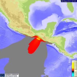
Tsunami waves reaching more than 3 m (9.9 feet) above the tide level are possible along some coasts of Mexico.
Tsunami waves reaching 0.3 to 1 m (1 to 3.3 feet) above the tide level are possible for some coasts of Cook Islands, Ecuador, French Polynesia, Guatemala and Kiribati.
Tsunami waves are forecast to be less than 0.3 m (1 feet) above the tide level for the coasts of Colombia, Costa Rica, El Salvador, Hawaii, Honduras, Jarvis Island, Nicaragua, Northwestern Hawaiian Islands, Palmyra Island, Panama and Peru.
On shaky ground
Last week’s temblor may have relieved pressure in one of two “seismic gaps” in the subduction zone off Mexico’s coast, where tectonic plates grind past one another.
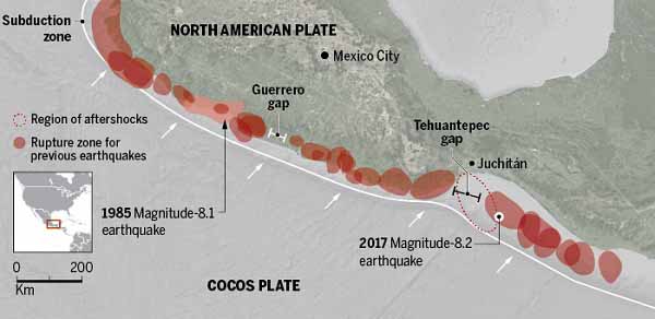
He concedes, though, that the quake’s effect on the gap is hard to judge, because of its unusual origin. Most big Mexican earthquakes occur right along the interface between the colliding Cocos and North American plates. But this rupture began 70 kilometers down, within the Cocos plate itself, and rose up before stopping at about 40 kilometers’ depth, likely at the plate interface. “It’s not the same fault that they’re expecting [to close] the Tehuantepec gap,” says Joann Stock, a seismologist at the California Institute of Technology in Pasadena.
That leaves the future risk of the Tehuantepec gap unclear. In fact, Stock says, last week’s quake might have even added stress at the gap and increased chances for future slipping. But, she adds, the depth of the shaking had at least one benefit: The rupture didn’t break through all the way to the ocean floor, which dampened tsunamis. The resulting waves in Chiapas and Oaxaca were only 2 to 3 meters high.
Vladimir Kostoglodov, a seismologist at UNAM in Mexico City, says he is fielding requests for data from researchers around the world who want to investigate this “extremely strange” earthquake and its aftermath. “It’s worth making a big effort to learn what’s happening,” he says. “This might happen in other subduction zones in other parts of the world.”
Sources of information
Websites:
https://earthquake.usgs.gov
http://earthjay.com/